Back ولاية صكتو Arabic Sokoto ştatı Azerbaijani سوکوتو ایالتی AZB Сокото Bulgarian Sokoto State Bislama Estat de Sokoto Catalan Sokoto (delstat) Danish Sokoto (Bundesstaat) German Sokoto State English Ŝtato Sokoto Esperanto
Paghimo ni bot Lsjbot. |
| Sokoto State | |
| Rima State, Sokoto | |
| Estado | |
| Nasod | |
|---|---|
| Gitas-on | 250 m (820 ft) |
| Tiganos | 13°05′00″N 5°15′00″E / 13.08333°N 5.25°E |
| Capital | Sokoto |
| Area | 25.97 km2 (10 sq mi) |
| Population | 4,244,399 (2013-02-07) [1] |
| Density | 163,435 / km2 (423,295 / sq mi) |
| Timezone | WAT (UTC+1) |
| ISO 3166-2 code | NG-SO- |
| GeoNames | 2322907 |
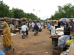
Estado ang Sokoto State sa Nigyeriya.[1] Nahimutang ni sa amihanan-kasadpang bahin sa nasod, 500 km sa amihanan-kasadpan sa Abuja ang ulohan sa nasod. Adunay 4,244,399 ka molupyo.[1] Naglangkob kin og 26.0 ka kilometro kwadrado. Sokoto State mopakigbahin sa usa ka utlanan sa Zamfara State, ug Kebbi State.
Ang yuta sa Sokoto State patag.[saysay 1]
Sokoto State may sa mosunod nga mga subdibisyon:
- Bodinga
- Sokoto North
- Sokoto South
- Yabo
- Wamako
- Gudu
- Binji
- Tangaza
- Gwadabawa
- Gada
- Sabon Birni
- Goronyo
- Isa
- Wurno
- Kware
- Rabah
- Silame
- Dange-Shuni
- Tureta
- Shagari
- Tambuwal
- Kebbe
- Illela
Sa mosunod nga mga natural nga mga bahin makita sa Sokoto State:
- Mga kalapukan:
- Mga suba:
- Bobo (suba)
- Dan Dutse (suba)
- Faranja (suba)
- Gulbin Majia (suba)
- Gurunzumi (suba)
- Jonga (suba)
- Kagatakowa (suba)
- Rafin Sh'Aibi (suba)
- River Albo (suba)
- River Alfa (suba)
- River Algali (suba)
- River Babulada (suba)
- River Bamana (suba)
- River Baori (suba)
- River Bella (suba)
- River Bella Bornu (suba)
- River Daaki (suba)
- River Dankado (suba)
- River Dankeji (suba)
- River Danogaba (suba)
- RIver Daramboa (suba)
- River Dibo (suba)
- River Fadama (suba)
- River Ferakam (suba)
- River Gadabo (suba)
- River Gagere (suba)
- River Gavangulbe (suba)
- River Gele (suba)
- River Gorondama (suba)
- River Gudu (suba)
- River Hoko (suba)
- River Illa (suba)
- River Kadeche (suba)
- River Karfin (suba)
- River Karkasi (suba)
- River Katsura (suba)
- River Kebbe (suba)
- River Kitchura (suba)
- River Kondolache (suba)
- River Kporaye (suba)
- River Kutumbu Mochera (suba)
- River Kwarare (suba)
- River Maica (suba)
- River Maijijemailu (suba)
- River Maila (suba)
- River Majiya (suba)
- River Majja (suba)
- River Maliba (suba)
- River Maniawa (suba)
- River Marumaru (suba)
- River Masaka (suba)
- River Muza (suba)
- River Nelba (suba)
- River Nelbru (suba)
- River Sabley (suba)
- River Salba (suba)
- River Shela (suba)
- River Shela (suba)
- River Sinkafatu (suba)
- River Sokoto (suba)
- River Sudiundu (suba)
- River Takoda (suba)
- River Tanfaga (suba)
- River Uda Sofo (suba)
- River Udanmata (suba)
- River Udasoba (suba)
- River Yamiriru (suba)
- River Yarcadi (suba)
- River Zage (suba)
- River Zamache (suba)
- Mga lanaw:
- Mga bungtod:
- Dan Dutsi Hill (mga bungtod)
- Dangade Hills (mga bungtod)
- Dumai Hill (bungtod)
- Jabba Hills (mga bungtod)
- Kolo Hill (bungtod)
- Mai Hills (mga bungtod)
- Sidi Hills (mga bungtod)
- Yami Hill (bungtod)
- Zolo Hill (bungtod)
- ↑ 1.0 1.1 1.2 Cite error: Invalid
<ref>tag; no text was provided for refs namedgn2322907 - ↑ Cite error: Invalid
<ref>tag; no text was provided for refs namedvp
Cite error: <ref> tags exist for a group named "saysay", but no corresponding <references group="saysay"/> tag was found
© MMXXIII Rich X Search. We shall prevail. All rights reserved. Rich X Search

